
Team 4A 2024: Diving into the digital abyss – Simulating deep-sea mining effects
Digital Twins and Ocean Mining
Our challenge was to investigate how we might design, implement or apply a digital ocean twin for the benefit of society and the environment. A digital ocean twin is effectively a complex computer model of the ocean that integrates physical, chemical and biological processes, and incorporates observational data. These twins will help us to learn more about our oceans and investigate the impacts of human activities, hopefully enabling the regulation of these activities to protect vital marine ecosystems.
While it might be our ultimate goal, a general-purpose twin of the whole planet’s ocean will be incredibly challenging to build. Instead, we decided to narrow our focus to create a twin to study the effects of deep-sea mining: an industry that is likely to have a huge impact on the oceans in the near future. In particular, we focussed on the Clarion-Clipperton Zone (CCZ), a deep, open region of the North-East Pacific with abundant polymetallic nodules growing on the sea floor. These nodules are rich in manganese, nickel, copper and cobalt: metals that are becoming increasingly important for the transition to renewable energy. The CCZ has been relatively well-researched compared to other potential mining sites, with several simulated mining studies that can be used to validate our model, but no commercial operations have yet started. A digital twin of this area is needed now more than ever, so that governing bodies like the International Seabed Authority (ISA) can create regulations before mining companies start churning up the ocean floor.
The Problem
The difficulty in creating such a twin lies in the multitude of data types that are needed to fully assess the impact of mining. Physical ocean variables like current velocity, temperature and salinity are fairly well-understood, but the impact from mining will also depend on the composition of the sediment that is churned up, and the biodiversity of the areas where it is happening. These data are much more difficult to collect, with only a few of sediment cores and biological surveys that have been taken across the CCZ. To create a model with enough resolution and accuracy to be useful to governing bodies, mining companies and scientists, these sparse data must be interpolated to form a consistent, continuous field with the physical ocean data.
A secondary problem is that current ocean models are complex and require lots of coding experience to utilise properly. Our digital twin would therefore have to have an open and accessible interface that non-experts in government and the mining industry could use to extract the data they need, while ensuring reproducibility and extensibility for scientists.
Gathering and Processing Data
The current state-of-the-art general circulation models already predict ocean currents, temperature and salinity well, so, after benchmarking and validation to ensure they are accurate enough, we can use these existing models to provide the physical data for the digital twin. The patchier sediment data and the distribution of species and polymetallic nodules, however, will require interpolation. The simplest way to achieve this is just averaging the values based on the distance between sampling sites, but this will give a “blurry” picture that is not high-resolution enough for informing mining operations.
However, these properties are likely to vary as a function of the distance from land and the depth of the ocean, in addition to the physical ocean variables mentioned above. The sediment cores and biological / nodule surveys that we do have can therefore be used to train a machine-learning model that can predict the properties of the sediment and ecosystem based on these much better-known parameters (Figure 1)
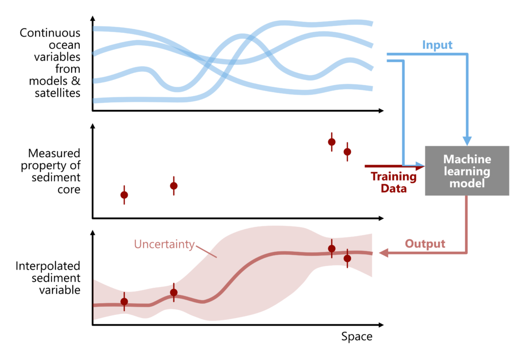
Figure 1: How we can use machine learning and physical ocean variables to interpolate between sediment cores with greater accuracy
For example, if satellites can observe a large quantity of chlorophyll from algal blooms in the surface water, this is likely to correlate with a high organic carbon content of the sediment, which would raise CO₂ through increased respiration if it were to be suspended by mining.
Visualising the Impact of Mining
Once we have created a layered, consistent model, we can run numerical simulations to assess the severity of the various consequences of ocean mining (Figure 2) in different locations. We can again correlate these impacts with the high-resolution properties of the model, enabling us to calculate a “mining impact score” for each part of the sea floor that is modelled. This will distil the data into an easily understandable, three-tier framework, which could quickly identify suitable (or unsuitable) areas for further investigation.
The impact score, along with the other layers of the digital twin, will be visualised using a customisable web interface (Figure 3), making the outputs accessible to non-experts from mining companies, governing bodies, and the public. To enable further research by scientists, the model results can be downloaded in GIS-compatible formats, and, to ensure reproducibility, the raw data that was used to train the model can also be shown and downloaded, where intellectual property rights allow.
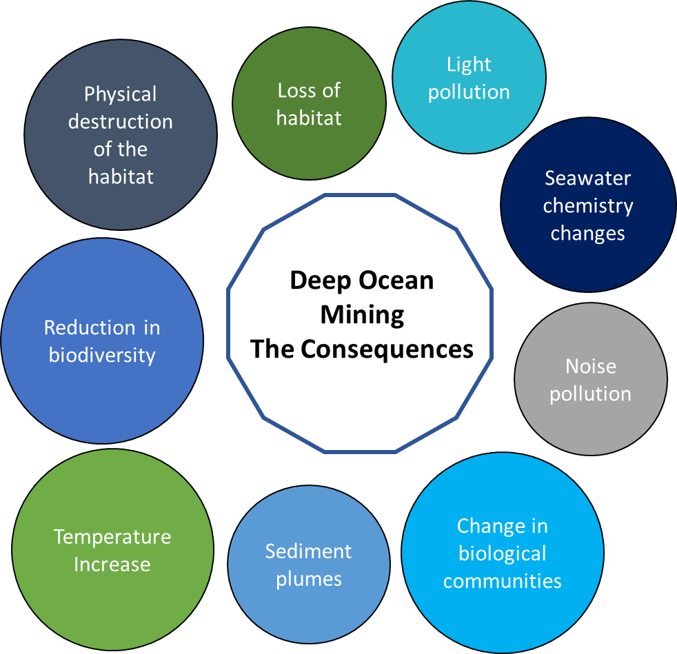
Figure 2: The various consequences of deep ocean mining that would be factored into the mining impact score
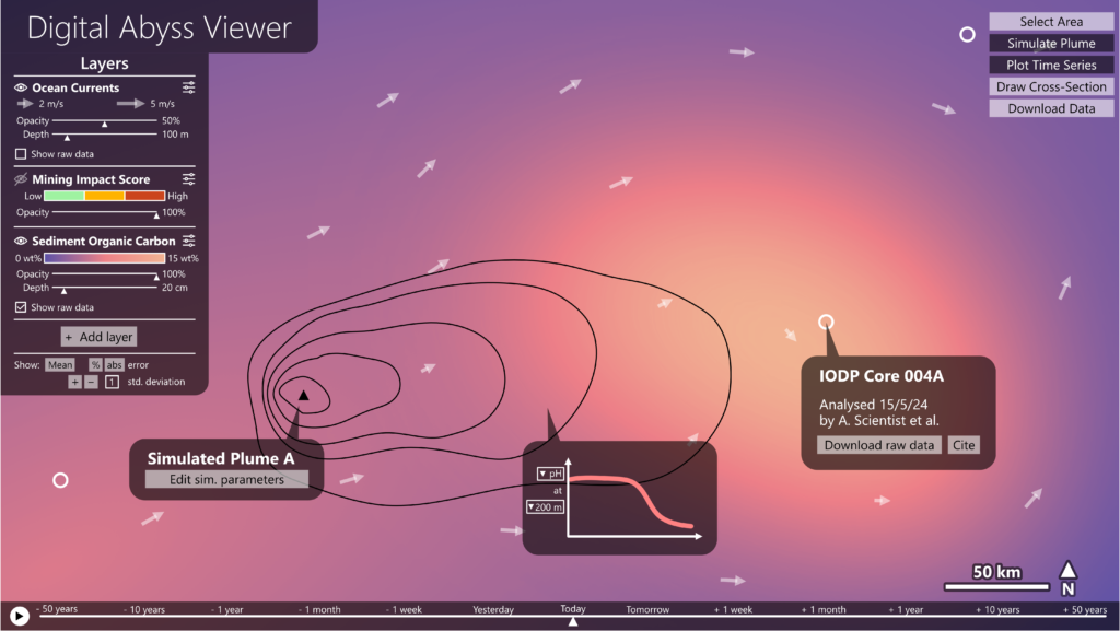
Figure 3: Mock-up of the interface for viewing the model data, currently showing ocean currents and the interpolated levels of organic carbon in the sediment, and the raw data sources that were used to construct the map.
Benefits of the Digital Abyss
The Digital Abyss twin would be a vital tool for governing bodies like the ISA, helping them design their policies for deep ocean mining, and to define regions where mining is permitted or restricted. Mining companies would also benefit. Parameters like the number of nodules in a particular area can be estimated using the same methods as the rest of the model, enabling them to identify the most economically-productive areas to mine, as well as having clarity on where they can and cannot mine while staying within the regulations. Researchers can also use the twin to improve our holistic understanding of the deep ocean, which still has many mysteries to solve. The framework underlying the twin could also be expanded to work for other ocean basins and marine interests, rather than developing entirely new models. The Digital Abyss would therefore be an important step on the way to a consistent general-purpose digital twin of the whole ocean.
Even when its scope is limited to mining in the CCZ, our digital twin would be one of the most complete models of the deep ocean ever created. While it would be achievable with our current levels of technology, creating the Digital Abyss would require significant resources to collect the required data, provide computing power for the processing, simulation and visualisation, and to fund the required research and software development. We believe that the numerous benefits for governments, management and regulatory bodies (e.g., the ISA), scientists and mining companies will motivate them to provide the funding and data that is needed to make the project happen.